A Legacy of Accuracy: Serving Ohio Since 1991

do things right and do the right thing.

Since our founding in 1991, Deibel Surveying, Inc. has evolved from a specialized construction layout and boundary survey company into a full-service land surveying firm. We proudly serve clients across Ohio, providing a wide range of surveying services including boundary surveys, construction staking, topographic surveys, ALTA/NSPS land title surveys, flood elevation certificates, site plans, and more.

Our small, highly skilled team of licensed land surveyors and design professionals is cross-trained in all aspects of our operation. This allows us to provide personalized service, with quick response times and consistent project follow-through. We prioritize being proactive over reactive, ensuring that potential issues are identified and resolved early in the process.

Let Deibel Surveying Help Make Your Next Project a Success

Let’s make your next project more successful together.
At Deibel Surveying, our team of licensed land surveyors, experienced engineers, and design professionals is here to guide your project from start to finish. Whether you need boundary surveys, construction staking, topographic surveys, or site planning, we deliver accurate results with precision and care. Trust Deibel Surveying to provide the expertise and dependable land surveying services you need to keep your project moving forward.

Professional Surveying Services

Mapping. Topography. Boundaries. Volumetrics

We proudly serve Stark County as our primary service area, while also offering extensive land surveying expertise throughout Columbiana County, Summit County, Carroll County, Tuscarawas County, and Portage County. Our firm holds the complete survey records of Ed Browne and Associates—a respected second-generation surveyor in Columbiana County—giving us a unique advantage in providing fast, accurate, and historically grounded surveys in that region. Whether you’re in Canton, Alliance, Lisbon, or surrounding communities, DSI Ohio delivers precise and efficient land surveying solutions backed by decades of experience.

ALTA/NSPS Surveys:

We provide American Land Title Association/National Society of Professional Surveyors surveys, ensuring comprehensive and accurate property data.

Boundary Surveys:
Our team conducts thorough boundary surveys in accordance with OAC 4733-37, establishing precise property lines through meticulous research and fieldwork.
Construction Surveys:

We offer detailed construction surveys, including layout and staking services, to support various phases of construction projects.

Volumetric Surveys:
Utilizing GPS and drone technology, we perform volumetric surveys to measure stockpile volumes accurately, aiding in inventory management and planning.
Aerial Mapping:

Our UAV-based aerial mapping services deliver high-resolution, geo-referenced images and 3D models, facilitating efficient planning and analysis.

Bathymetric Surveying:
We conduct bathymetric surveys using sonar and RTK GPS to map underwater terrains, providing essential data for environmental and engineering projects.
Oil & Gas Industry Services:
Located in the heart of the Utica and Marcellus shale plays, we offer specialized surveying services tailored to the oil and gas sector.
Residential
Residential Surveys Fast, affordable surveys for homeowners needing plot plans, mortgage surveys, or boundary confirmations.
Topographical
Topographical Surveys Accurate land elevation and contour mapping to support engineering, drainage, and site design work.

Deibel Featured Projects

These featured projects represent our commitment to precision, efficiency, and customer satisfaction

At Deibel Surveying, we are proud to showcase a selection of recent land surveying projects completed by our experienced survey crews. Each project highlights the wide range of land surveying services we provide, from boundary surveys and construction staking to drone mapping.

Jackson Middle School future land use
When Jackson Middle School needed a topographical survey for future land use, they turned to Deibel Surveying.
Stark County Dog Warden facility renovation and addition
This topographical survey of the Stark County Dog Warden property on Mahoning Road NE will be used as a base map.
Housing development on former farm
Deibel Surveying did this topographical survey for a housing development on a former 80-acre farm in Tuscarawas County, OH.

What our customers have to say

Surveying Success Stories Across Ohio

Deibel Surveying Blog

Expert Tips, Industry News, in Surveying and Land Development

Is surveying art or science? What is your opinion?

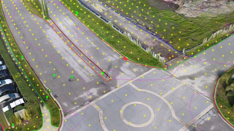
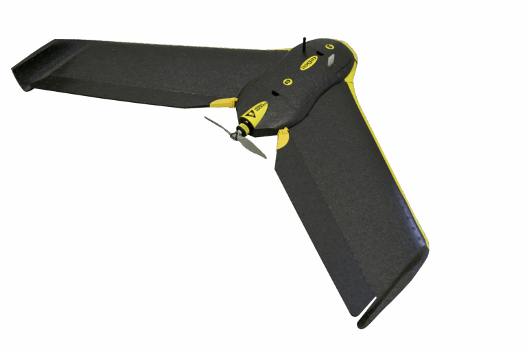
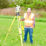
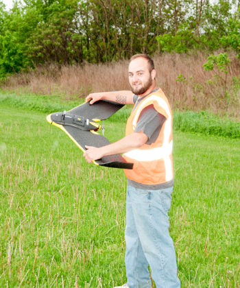
Is surveying an art or a science? That is a question worthy of consideration, because our profession certainly has facets of both. Some elements of surveying are technology based, making it a science, and some are related to history, law, evidence and interpretation, making it an art. The tools we

Read More »

senseFly Launches New Corridor Mapping Solution

senseFly has announced the release of senseFly Corridor, a new platform enhancement that simplifies the drone mapping of linear infrastructure and sites. It makes its debut at AUVSI Xponential in Dallas. Corridor mapping is a common task for many geospatial professionals and important for the effective planning, design and analysis

Read More »

Our Commitment to Excellence

real and sustainable solutions for our clients

Professionalism, accuracy, and integrity are at the core of everything we do. Our clients include homeowners, contractors, engineers, developers, and local government agencies who rely on our dependable land surveying services throughout Ohio. From small residential projects to large commercial developments, Deibel Surveying delivers reliable results backed by decades of experience and cutting-edge technology.

When you choose Deibel Surveying, you are partnering with a team that values quality, responsiveness, and doing what’s right for every project.

Companies and Municipalities

We serves private clients, public agencies, and municipalities.

Let’s Discuss Your Project Needs Today

Partner with a trusted surveying team that delivers accuracy, reliability, and results—on time and on budget.

Whether you’re developing land, planning construction, or need precise data for real estate or environmental work, Deibel Surveying Inc. is here to help.

Nathan Deibel
Survey Crew

Education:
Currently pursuing Bachelor of Surveying and Mapping, University of Akron

Professional Experience:

  • Survey Crew, Deibel Surveying, Inc., Canton, OH (2004-Present)
Jeordan Burkhart
Survey Crew

Professional Experience

  • Survey Crew, Deibel Surveying, Inc., Canton, OH
  • Field Crew at another firm
Aran Deibel
VP/Project Manager

Education

  • Bachelor of Specialized Studies, Ohio University (March 2000)
  • Bachelor of Surveying and Mapping, University of Akron (December 2011)

Professional Experience:

  • Deibel Surveying, Inc., Canton, OH (2005-Present)
  • Project Manager/Estimator/Controller/Survey Party Chief, American General Finance, San Francisco, CA (2000-2005)
  • District Manager, Deibel Surveying, Inc., Canton, OH (1991-2000)
  • Field crew during school breaks
Curtis G. Deibel
P.S. President/Professional Land Surveyor (#6673)

Education: Bachelor of Science Degree, Mathematics, Kent State University (June 1975)

Professional Experience:

  • Deibel Surveying, Inc., Canton, OH (1991-Present)
  • President, The Beaver Excavating Company, Canton, OH (1980-1991)
  • Head of Survey Department, Hammontree & Associates Ltd., Canton, OH (1979-1980)
  • Survey Party Chief, Robinson, McKelvey and Assoc., Gaylord, MI (1978-1979)
  • Survey Party Chief, Friedl and Harris, Inc., Canton, OH (1972-1977)
  • Field Crew