We have prepared a list of frequently asked questions to help you clarify any doubts. You can also contact us and we will be happy to answer your request.
Professional Surveying Across Stark, Columbiana, Tuscarawas, Summit, and Portage Counties
Based in Stark County, Ohio, DSI Surveying has built a reputation for accuracy and reliability, serving clients across all 17 Stark County townships—Bethlehem, Canton, Jackson, Lake, Lawrence, Lexington, Marlboro, Nimishillen, Osnaburg, Paris, Perry, Pike, Plain, Sandy, Sugarcreek, Tuscarawas, and Washington.
We are also the trusted choice for surveying in Columbiana County, where we hold all of Ed Browne’s original survey records, giving us access to decades of historical boundary and property data for unmatched accuracy.
Our services extend throughout Tuscarawas, Summit, and Portage Counties, where we provide the same level of precision, professionalism, and advanced surveying technology to ensure every project is completed correctly the first time.
Stark County, Ohio
As our home base, DSI Surveying provides trusted surveying services throughout Stark County, covering all 17 townships: Bethlehem, Canton, Jackson, Lake, Lawrence, Lexington, Marlboro, Nimishillen, Osnaburg, Paris, Perry, Pike, Plain, Sandy, Sugarcreek, Tuscarawas, and Washington. Our in-depth knowledge of Stark County land records and regulations ensures highly accurate boundary surveys, construction layouts, ALTA/NSPS surveys, and residential site plans for both private and commercial projects.
Columbiana County, Ohio
In Columbiana County, DSI Surveying offers a distinct advantage—we hold all of Ed Browne’s original survey records. This exclusive access to decades of historical survey data allows us to verify boundary lines, property corners, and easements with unmatched precision, saving our clients time and reducing the risk of costly property disputes. From topographic surveys to construction layouts, we are the go-to surveying team for Columbiana County.
Tuscarawas County, Ohio
DSI Surveying delivers reliable and cost-effective surveying solutions throughout Tuscarawas County. Our familiarity with local land conditions and development requirements helps property owners, contractors, and developers complete projects quickly and accurately. We specialize in boundary, topographic, and ALTA/NSPS surveys, as well as residential and commercial site planning.
Summit County, Ohio
In Summit County, we provide precision surveying for residential, commercial, and industrial projects. Whether you need a boundary survey for a real estate transaction or construction staking for new development, our experienced team ensures that every project meets county requirements and is completed to the highest professional standards.
Portage County, Ohio
Property owners and developers in Portage County trust DSI Surveying for dependable, accurate land surveys. We provide boundary surveys, ALTA/NSPS surveys, topographic mapping, and construction layout services that help streamline development projects and protect property investments.
Our services include boundary surveys, ALTA/NSPS land title surveys, topographic surveys, construction staking, flood elevation certificates, subdivision planning, lot splits, drone surveying.
You can call us at 330-455-2999, or fill out the contact form on our website’s Contact Us page.
The average turnaround time for a standard boundary survey is about two (2) weeks. Some smaller surveys may take only a few days, while larger or more complex projects can take up to a month.
No. A licensed surveyor must locate and verify all property corners with county monuments or prior survey records. This ensures the accuracy of the survey and prevents future disputes.
Per OAC 4733:37, only 1 line cannot be located as it does not relate to anything else (mathematically, other property lines, historical data etc)
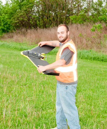
Yes. Our team uses advanced drone technology along with traditional survey equipment to capture high-resolution aerial images and produce detailed 3D models for site analysis and planning.
FAA #3959665
We work under Curt’s license.
Call us or fill out our online contact form. We will discuss your project, provide a quote, and schedule your survey at a time that works best for you.
Deibel Surveying has combined decades of experience with the latest technology to deliver accurate, efficient, and reliable land surveying services. Our team is committed to integrity, customer service, and getting the job done right.
Have more questions? Please let us know.
Whether you’re developing land, planning construction, or need precise data for real estate or environmental work, Deibel Surveying Inc. is here to help.
Education:
Currently pursuing Bachelor of Surveying and Mapping, University of Akron
Professional Experience:
Professional Experience

Education
Professional Experience:

Education: Bachelor of Science Degree, Mathematics, Kent State University (June 1975)
Professional Experience: